
Map Pharr Postal Coverage
Official source material located for Pharr supports one primary postal association: 78577 is listed as Pharr, Texas, in Hidalgo County. That is the complete supported list, not proof that the ZIP boundary matches the incorporated city. The research did not locate an official USPS page that enumerates every ZIP boundary or all postal codes touching Pharr. Nearby Hidalgo postal cities can appear in wider Rio Grande Valley searches, but they should not be labeled as Pharr service areas without a USPS or city-boundary source.
| ZIP | Areas Covered | Post Office | Notes |
|---|---|---|---|
| 78577 | Pharr, Texas, as identified in the official Texas ZIP list | Not stated in the official sources reviewed | Primary Pharr association supported by the located sources; boundary extent was not enumerated. |
The official Texas ZIP list is the state-list evidence for 78577. For a specific delivery address, use USPS rather than assuming that every address with a Pharr mailing city lies inside Pharr’s city limits.
Check Pharr Postal Evidence
ZIPs are delivery-routing constructs, not municipal boundary maps. The USPS explanation of ZIP basics describes a five-digit ZIP as a delivery area and ZIP+4 as the finer routing extension. This distinction matters when a tax, deed, permit, library, or voter source uses a city name, a parcel location, or a mailing address. Preserve the source’s wording and identify which geography it actually records.
The recorded research gap is important: no official source was found that lists every ZIP boundary around incorporated Pharr. A ZIP result can therefore narrow a search, but it cannot prove a municipal boundary or establish that a person resides within city limits. Use the city or county map layer for that question and the full address for the postal question.
The USPS ZIP Code basics reference captured for this Pharr ZIP code directory shows the agency’s explanation of five-digit ZIP Codes and ZIP+4 routing.
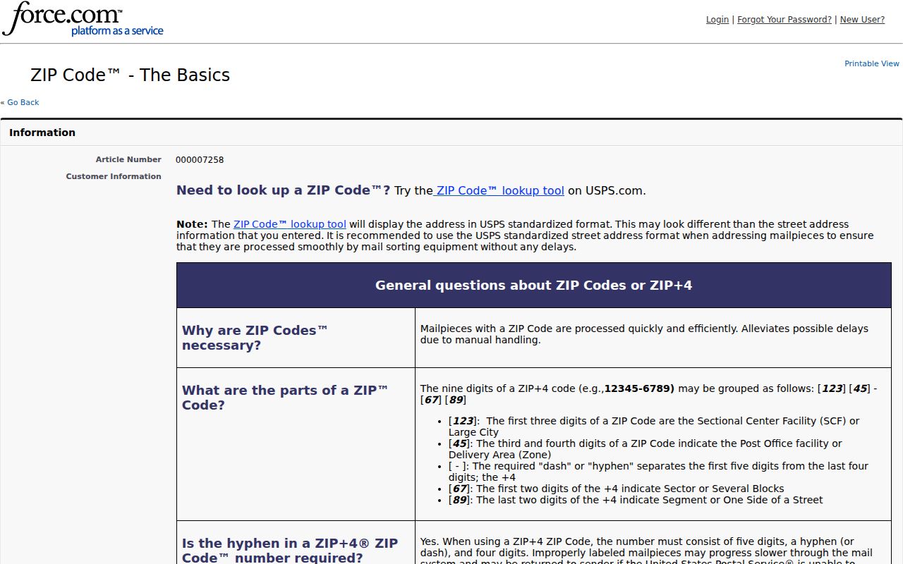
That distinction is why a complete delivery address should be validated before it is used to compare a parcel or a city-held address record.
Find Pharr Records Within a ZIP
A ZIP can organize an address search, but the official systems reviewed do not provide one combined ZIP-wide resident result. Start with the address, then use each custodian’s actual field. The tax portal is address, owner, account, CAD reference, or fiduciary based. The individual voter route is based on VUID, qualifying driver-license information, or a first and last name. The County Clerk records portal searches parties, subdivisions, document types, document numbers, and recorded dates.
- Validate the complete mailing address with USPS. Keep the ZIP+4 and unit when they are present.
- Search the Hidalgo County tax portal by property address and retain the account number or CAD reference.
- Compare the location with the Hidalgo County Appraisal District and its map context, then check the legal description if the parcel is unclear.
- Use the Hidalgo County Clerk official-records search for the parcel’s recorded-deed or plat trail.
- Check city limits with city or county maps before treating the mailing ZIP as a Pharr municipal result.
- Request an existing city or county record from the custodian when a permit, map, plat, or administrative file is not online.
Once a ZIP has narrowed the address, the Pharr street directory gives the fuller street-by-street sequence. Do not treat a search hit from any single system as a complete or current household list.
Use Pharr ZIP Code Search Fields
The county tax portal was the real address-capable property tool documented in the research. Its published controls do not include a ZIP field, so it should not be described as a ZIP-wide filter. It uses a two-stage search: choose a first criterion to find a property, then apply an optional second criterion where needed. The address choice is marked “Starts With,” and the site prints examples for owner name, account number, CAD reference, and property address.
| Portal field | Available stage | ZIP research use |
|---|---|---|
| Owner Name | First or optional second criterion | Can narrow a property after the address is validated; no ZIP field is documented. |
| Property Address | First or optional second criterion | Use the postal-validated street line. First-stage searching is “Starts With.” |
| Account No. | First or optional second criterion | Use after an address result establishes the tax-account key. |
| CAD Reference No. | First or optional second criterion | Use to connect tax material with appraisal context. |
| Fiduciary No. | First criterion | Available on the portal, but not a ZIP-specific search control. |
HCAD’s current official site is the appropriate appraisal route, but its interactive search-field inventory was not exposed in official page text during research. The safer process is address first, then account or CAD reference, then parcel, legal-description, and recorded-document comparison.
Match Pharr ZIPs to Parcels
A mailing ZIP should be compared with the parcel rather than only with a city name. Hidalgo appraisal and tax sources may display a location address, mailing address, parcel or account key, legal description, and public valuation fields. The County Clerk can then supply a deed, plat, lien, release, or other recorded instrument. A mailing address may differ from the property location, and neither should be silently substituted for the other.
The official HCAD material says the district uses GIS for Hidalgo parcels. The regional basemap includes parcel outlines, roads, subdivisions, building footprints, city limits, county boundaries, and civic layers. It is useful for visual orientation, but its exact query inventory and update date were not inspected. Official GIS boundaries are informational and approximate, not a legal survey, so use the deed or legal description where legal boundaries matter.
Note: Keep the tax account, CAD reference, parcel location, and postal address as separate fields until the sources show that they describe the same property.
Place Pharr ZIPs in Context
Postal research in Pharr often points beyond a single map layer. The city lies in Hidalgo County in the Rio Grande Valley, while property, court, and elections records are generally county systems and municipal permits or code files remain city systems. Historical research can move between county books, local newspapers, library collections, and state repositories. Keeping the postal, city, county, parcel, and historical layers labeled prevents a result from being assigned to the wrong jurisdiction.
Pharr’s official history describes a shift from agricultural roots toward trade and industrial identity. The Pharr-Reynosa International Bridge received a Presidential Permit in 1978 and became operational in 1994. Those dates are useful for researching a dated local event, business, bridge, or council record, but they do not define a ZIP boundary. Use them as historical search anchors only after the address and jurisdiction have been verified.
Keep Pharr ZIP Units Separate
ZIP+4 is not a different city boundary. It adds four digits to a five-digit ZIP for finer delivery routing. An apartment or unit is a separate part of the street line and should not be dropped when comparing a tax record, a deed, a permit, a voter item, or a library source. Omission can merge distinct addresses. Preserve the source’s original formatting in notes, then make a normalized comparison copy only for searching.
- ZIP
- A five-digit postal delivery area used by USPS routing.
- ZIP+4
- The four additional digits that refine delivery routing within a ZIP.
- PO-box ZIP
- A ZIP used for post-office boxes rather than a claim about a street-address boundary. No Pharr PO-box ZIP was confirmed in the research.
- Unique ZIP
- A ZIP associated with one institution or organization. No unique Pharr ZIP was confirmed in the research.
- Carrier route
- A delivery-route grouping. The research did not identify a public Pharr carrier-route search.
Read Pharr Voter ZIP Limits
Texas voter tools are not ZIP-by-ZIP resident directories. The official statewide status route uses VUID, qualifying Texas driver-license information, or first and last name. Hidalgo’s sample-ballot lookup asks for first name, last name, and date of birth. Its result can identify an election ballot or district context, but it should not be used as proof of current residence. Public voter data also has protected fields and address-confidentiality procedures for qualifying people.
The Hidalgo sample-ballot lookup captured for the Pharr ZIP code directory displays the name and date-of-birth controls used to reach ballot information.
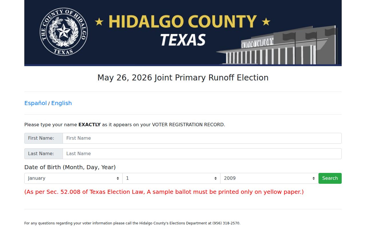
The interface illustrates why that election tool should remain a name-and-ballot route, while postal validation and parcel records handle address and ZIP comparisons.
Texas also offers a statewide voter-file request through SOS Form 24-2. The form has selections for status, date ranges, and reductions by Texas mailing address, and the file layout includes mailing-address components. It requires a notarized affidavit and a deposit before delivery. It is a state request route with use restrictions, not an official map of every Pharr ZIP boundary.
Separate Pharr ZIPs From Limits
Postal ZIP boundaries and Pharr city limits are different layers. A complete mailing address should be tested with USPS first, then checked against city or county map context and the parcel’s legal description. If a property uses a Pharr mailing city but falls outside city limits, label that distinction plainly. The same care applies when comparing county, city, postal, parcel, census, and historical records, because each one is built for a different geographic purpose.
For a city-held address, permit, or map record, use the Pharr Public Information Request process. For an existing county record, use the Hidalgo County request instructions. Both routes require a written request and work best with a location, date range, and specific existing record description.
When the online route is incomplete, Pharr Development Services, the County Clerk, the Tax Office, and HCAD provide the documented in-person or phone fallback. The historical fallback is the library and archive route, including TSLAC maps and newspapers for earlier street names or dated address context. Ask the custodian for an existing record instead of asking it to construct a ZIP-wide list.